News | DrumhellerMail - Page #631
04192024Fri
Last updateFri, 19 Apr 2024 5pm

Hanna RCMP warn of new scam

police jacket 1

The Hanna RCMP are alerting residents of a new scam they uncovered last week.
The caller identifies themselves as law enforcement but not from the local police (in this case, RCMP from Ontario). The caller goes on to make the potential victim believe there is an investigation into the activities of a suspect in Hanna that is stealing money from bank accounts and sending it to someone in another part of Canada.
The reality is, however, there is no investigation, no suspect in Hanna and the caller isn’t a real law enforcement officer. The caller then tells the potential victim they could help by sending a large quantity of cash in the mail so they (the fake police) would be able to catch the people in the other province. The victim then sends money in the mail which is ultimately never seen again.
There is no investigation and the caller is simply scamming the victim into sending the cash.
They will pressure you into not saying anything to anyone, even the local police. Do not ever send money to someone without verifying the details of the transaction. If someone calls you and asks you to send money, DON’T. It is more than likely a scam. Tell the caller you want to verify the transaction before sending the money.
The RCMP nor any other police agency will ever tell you to send money to assist with an investigation.
You will always have time to verify a transaction. If anyone pressures you, it is a scam. Do not send the money.


Flood mitigation office working on final design

Colberg Durnie 55million

The Resiliency and Flood Mitigation office is continuing work on the design phase of the project and hopes to have a working document in their hands in the near future.
Many residents are asking what the project will look like and how it will affect them.
Chief Resiliency and Flood Mitigation officer, Darwin Durnie, says while they have been in contact with many landowners, they are waiting on the designs to move forward.
“We are preparing 95 per cent complete design drawings that we can use to contact landowners that we will need their land to protect them and their neighbours,” he said. “We’re creating sketches of their property that show the impact of the land taking and preparing value appraisals to try to define what the values of our offers will be.”
Because these are sensitive negotiations, he says they are respecting the confidentiality of homeowners as they deal with these decisions. These are one-on-one meetings, and so far they have had about 80 of these.
Durnie said originally, they were hoping to have these designs in April, but they have been delayed. Like many projects, the flood mitigation program in the valley has felt the pandemic, making it difficult to have site meetings and work collaboratively on plans and documents.
The regulatory process has also been time-consuming. They are dealing with more than 50 agencies whereby they have to get approvals. There are both federal and provincial, everything from Fisheries and Oceans to historical and palaeontological resources.
“We have been working really hard with the regulators to work with them based on long-standing relationships with them to be able to accelerate the process,” he said.
Another time-consuming effort by the office is making a case to the province to use regulated flow rather than the natural flow as a benchmark for the flood mitigation project.
There is no certain timeline for the completion of the design work.
He says the project is a collective effort to protect the community.
“We talk about the need for this is to ensure property value is maintained with regards to insurance now and in the future, and that translates into the ability to get a mortgage. Some of the interactions I have had with folks, some along the river say ‘I’m okay if I get flooded out and stand on my own without insurance.’ I say, ‘Okay but I’m not sure if your neighbours are, two blocks inwards.’”
Durnie explains the project will proceed as they receive approvals and secure land. One portion of the plan to proceed with early is dike work near Rosedale between the Rosebud River and the wastewater treatment plant.
“We are using that as our test case with all the regulatory agencies,” he said, “to see if we can get everybody signing off on this.”
One fear of some landowners is the possibility of hiking trails along the length of the mitigation. Durnie says there will be segments that would be paved, and in the future, there could be more use of the areas.
“Public infrastructure, paid for by public money, should have public access. I don’t think Drumheller can afford to build as much trails as people think, but we can’t handcuff a future council,” he said. “There will be segments of the trail in highly public areas that will have a hard surface.

Dickson Dam plays critical role during flood season

DSCF0207

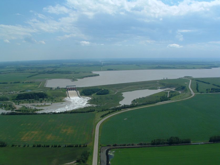
Dickson Dam, located approximately 180 kilometres northwest of Drumheller on the Red Deer River, plays a key role in the ongoing flood mitigation efforts in the Drumheller Valley through flow regulation and communication with municipal operators.
Director of North Central Region of Alberta Environment and Parks, Water Infrastructure, and Operations Branch Rick Friedl was one of the operators involved at Dickson Dam during the 2005 flood event and took time to speak with the Mail to explain the purpose of the dam and its role in the 2005 and 2013 flood events.
“The primary purpose of the Dickson Dam is to provide assured water supply year-round downstream,” Friedl says. He explains his group’s region is responsible for operations and maintenance of multiple water infrastructure throughout central Alberta, including the dam.
Prior to the construction of Dickson Dam in 1983, water flow in the Red Deer River would drop as low as two cubic metres per second in winter months.
Through capturing and storing water in the reservoir throughout spring and summer months, operators are able to supplement river flow during winter months to maintain a consistent minimum flow of 16 cubic metres per second. This in turn provides higher water quality for fish, aquatic wildlife, and human consumption, while also generating a peak 15 megawatts of hydroelectric power as water flows from the reservoir.
As water levels in the reservoir decrease throughout the winter months, empty storage space is created which operators can then use to help attenuate potential flood events. However, by late-May to early-June the reservoir fill cycle begins to ensure it is full coming into the next winter cycle, thereby reducing the amount of available storage.
Friedl notes flood attenuation is a “complex task,” and success is dependent on a number of factors ranging from storage availability in the reservoir, and the amount of notice operators are given for a potential flood event--both of which can vary on each given year.
“Historically, Dickson Dam has done a very good job attenuating flood events on the Red Deer River, to the point the downstream impacts related to small and medium sized floods are reduced,” he said. “However, large to extreme flood events have the potential to exceed the dam’s ability to provide attenuation.”
In large flood events, due to more flow into the reservoir, there is less attenuation. “Once the reservoir is full, inflows must equal outflows” he adds.
In 2005, one of the largest recorded floods for the Red Deer river basin, operators had only a few days’ lead time of an approaching storm at the headwaters of the Red Deer River.
Given the lead time, operators were able to reduce inflow at the reservoir from approximately 2,300 cubic metres per second to a peak outflow of 1,550 cubic metres per second downstream of the dam, which equates to a 30 per cent reduction in flow.
Friedl says, had the dam not been in place, water would have topped the existing dikes throughout the Drumheller Valley and would have resulted in worse damages. He also attributes the cooperation and coordination efforts between operators at Dickson Dam and emergency municipal operations within the community.
Designing the new dikes and berms to be adaptive will allow the Flood Mitigation Office to accommodate higher rates of flow than seen during the 2005 floods, and can work in conjunction with operations at the dam to provide an added layer of protection to vulnerable riverside communities such as the Town of Drumheller.


Subcategories

The Drumheller Mail encourages commenting on our stories but due to our harassment policy we must remove any comments that are offensive, or don’t meet the guidelines of our commenting policy.